

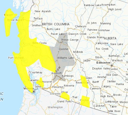
There is a wind warring for Haida Gwaii, North Coast coastal sections and Central Coast coastal sections. And rain fall warring for Bella Coola.
Environment Canada is saying that there is strong southeasterly winds of 90 kilometers per hour, with gusts reaching 120 kilometers per hour.
Expected along exposed coastal sections of the North Coast and Central Coastal region. From now till this afternoon.
As a frontal system is forecast to bring very strong winds to the northern and central coastal waters today.
The system will move out of the region this evening, with winds gradually easing in its wake.
Local utility outages are possible.
Parks and forests will likely sustain some damage.
There is a risk of injury due to flying or falling debris. Secure loose objects.
Meanwhile there is a rainfall warring for Centreal Coast inland sections.
As heavy rain is expected, with total rainfall amounts up to 60 millimeters, from now until tomorrow afternoon.
As a frontal system is approaching and is forecast to bring heavy rain to the region.
With the atmospheric flow aligned with the valley’s orientation, moisture associated with the system will be channelled into Bella Coola, bringing rainfall amounts of up to 60 millimeters between this afternoon and Friday afternoon.
This will be the first in a series of potent storm systems expected to bring periods of heavy rain and strong winds to the BC coast through next week.
Water will likely pool on roads and in low-lying areas. Visibility will likely be suddenly reduced at times. Watch for washouts near rivers, creeks and culverts.
And there is a special weather statement for the Cariboo – Prince George – 100 Mile House (Including Highway 97) – South Thompson.
Environment Canada says there will be moderate to strong gusty winds. Starting this evening till Friday evening.
A strong low pressure system will approach the B.C. coast this evening and will bring a prolonged period of southeast winds with gusts ranging from 60-70 kilometers per hour to the B.C. interior.
These southeast winds will pick up this evening and will peak by Friday morning.
Winds may ease slightly Friday afternoon before an incoming cold front will bring a strong push of southwest winds, with gusts potentially up to 90 kilometers per hour between Quesnel and Prince George.
Winds for the South Thompson region will peak Friday afternoon, with the strongest winds expected near Cache Creek.
A potentially stronger storm is set to follow on Saturday evening. Local utility outages are possible. Parks and forests may sustain damage. Secure loose objects.

